Thomas Jefferson was acutely aware of the great potential benefits offered by lands in the West. A growing population in the original states, now largely free from British interference, was beginning to push into these areas. Jefferson had earlier offered a systematic means to prepare new areas for statehood in his Ordinance of 1784. In the following year, he directed his attention to designing a system for surveying the lands that might avoid the pitfalls of earlier methods of determining boundaries.
Many landowners in the original states had become embroiled in ownership disputes because their property lines were defined in terms of rocks, streams and trees — any of which could disappear or be moved. Another nagging feature of the old system was that frugal purchasers would buy only the best pieces of land by carving out irregular plots that avoided undesirable wasteland. Early land ownership maps appeared to be jigsaw puzzles.
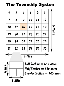
 Jefferson’s proposal was much more orderly. He advocated the creation of a rectangular or rectilinear system of land survey. The basic unit of ownership was to be the township — a six-mile square or 36 square miles. (Jefferson had actually favored townships of 10-mile squares, but Congress believed those plots would be too large and difficult to sell.) Each township was to be divided into 36 sections, each a one-mile square or 640 acres.
A north-south line of townships was to be known as a range.
Borrowing from a New England practice, the Ordinance also provided that Section 16 in each township was to be reserved for the benefit of Public Education. All other sections were to be made available to the public at auction.
The Ordinance provided that sections be offered to the public at the minimum bidding price of one dollar per acre or a total of $640. Jefferson and other members of Congress hoped that competitive bidding would bring in receipts far in excess of the minimum amount. The meager treasury of the Confederation sorely needed every dollar it could find.
The Ordinance of 1785 was landmark legislation. By preparing this means for selling Western lands, the government introduced a system that would remain the foundation of U.S. public land policy until the enactment of the Homestead Act of 1862. Modifications, however, would occur over the years as it became apparent that $640 was more than many could afford and, similarly, that 640 acres was too large for most family farms. Future legislation would keep the basic system intact, but reduce the minimum acreage requirement.
A revision of the statehood provisions for the Northwest came in the Northwest Ordinance of 1787.